Tour du Mont Blanc Detailed Planning Notes
June 26, 2019
Richard Moore
This is a collection of the detailed planning I did on routes, transportation and options for each day.
Here are day by day pictures of our trip and assorted comments.
http://themnmoores.net/Photos/BlogPages/TourduMontBlancPhotos/TourduMontBlancPhotos.html
Here is a work in progress about our trip, planning, execution and thoughts.
http://themnmoores.net/RichBlogs/2020/TourduMontBlanc/TourduMontBlanc.html
TMB Day 1: Chamonix to Les Houches
Pygmy write up of full itinerary
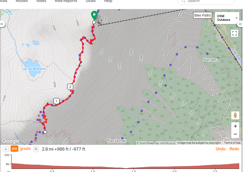
Distance: 3.5 to 4.5 hours / 6 Miles
Height gain: minimal / Height loss: 5,072 feet
Transport: Gondola to Le Brevant, Train to Les Houches is also possible from Chamonix (optional)
From Pygmy Elephant Blog:
You will first take the gondola up to the Le Brevant view point (8,287 feet) from the village of Chamonix. After taking in the scenery, start the long and continual descent down to Les Houches. This descent is often combined with another steep ascent to Le Brevant, however you will choose whether you would like to complete this section when you return 11 days later (this is the section from Le Flegerie to Le Brevant). Although the day will be a bit tough on the knees, the short distance makes this section much easier to handle.
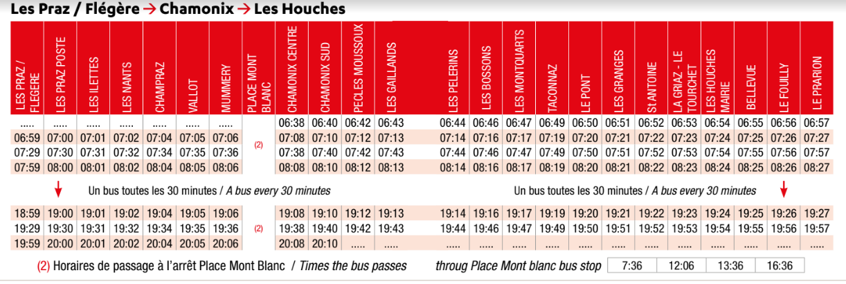
Our plan: Ride up to Le Brevent (Pygmy only mentions Planpraz, would Le Brevent would require a second cable car ticket? It was an additional cost). Walk to and back and take the cable car down, ride the bus to Les Houches to avoid about 4000 vertical feet of downhill!!! Buses run every 30 minutes, and cost 3 euro (Chamonix hotels provide transit tickets, does not seem the bus drivers actually check) This worked out pretty well.
https://www.chamonix.net/english/transport/bus
Hotel:
Hotel du Bois in Les Houches
475 Avenue des Alpages
74310 LES HOUCHES
Tel : +33 4 50 54 50 35
http://www.hotel-du-bois.com/en/accueil.htm
Food/Refugees along the way:
Refuge Bellachar (At Mile 1.5 on map, not open)
https://www.refuge-bellachat.com/
Take advantage of this break to quench your thirst and enjoy a small snack in front of Mont Blanc: omelets, soups, cold meats, cheese, salads, blueberry tart with your favorite drink. (Note: not rated very highly on google reviews 1.8 out of 5)
Altitude 2000M (a bit above the Plan Prez midway point on the tram)
Rated better on google reviews, is only a restaurant.
Brev Bar (a bit above the Plan Pres midway point on tram, closer than Altitude 2000)
http://www.brevbar.com/en/index.php?lang=en
May not be open in September?
Gares de Planpraz (At Halfway point for tram, looks like sandwiches and beverages)
Looks pretty casual, would be an easy place to stop on the way back down. It was
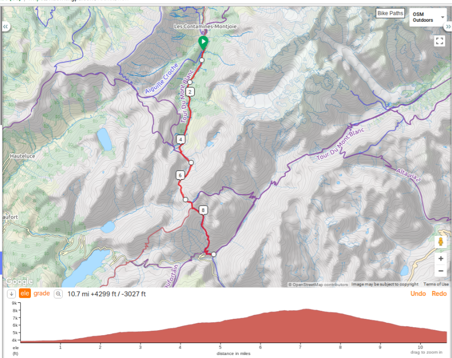
TMB Day 2: Les Houches to Les Contamine
This might be a good route:
Distance: 5.5 hours / 10 Miles (Main route)
Height gain: 2,120 feet / Height loss: 2,076 feet
Transport Options: Cableway Les Houches to Bellevue (halfway up first ascent), Train from neighboring St. Gervais to top of first ascent (Col de Voza), Bus from Tresse to Les Contamine
Traveling along the main TMB route, there is more road walking than other stages. Still, there are some decent views to be had, especially at Col de Voza. From there, you can see the Dome du Gouter and Aiguille de Bionnassay and the glacier that splits them in two. From Les Houches, it’s about 2.5 hours to Col de Voza (Col = saddle), which is also the high point of the trek at 5,423 feet. It’s then a relatively slow descent down again to Tresse and finally onto Les Contamine. Not a particularly demanding day, however multiple transport options are available to make this trek easier in case your knees are feeling rough from the day before. There is an alternative to the Main Route which provides better views and reaches higher altitude, but you will pay for it in effort. It's 2.5 hours longer and has over 2,400 feet more of elevation gain.
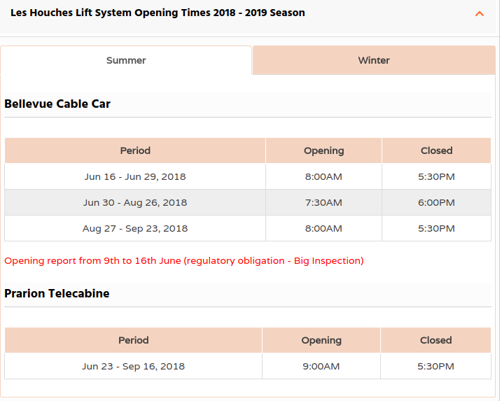
Lift option out of Les Houches https://www.chamonix.net/english/lift-systems
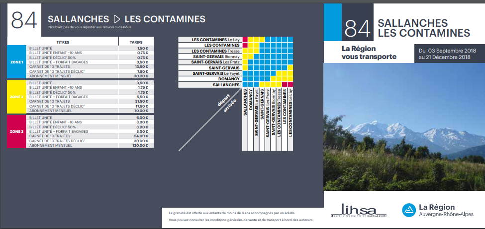
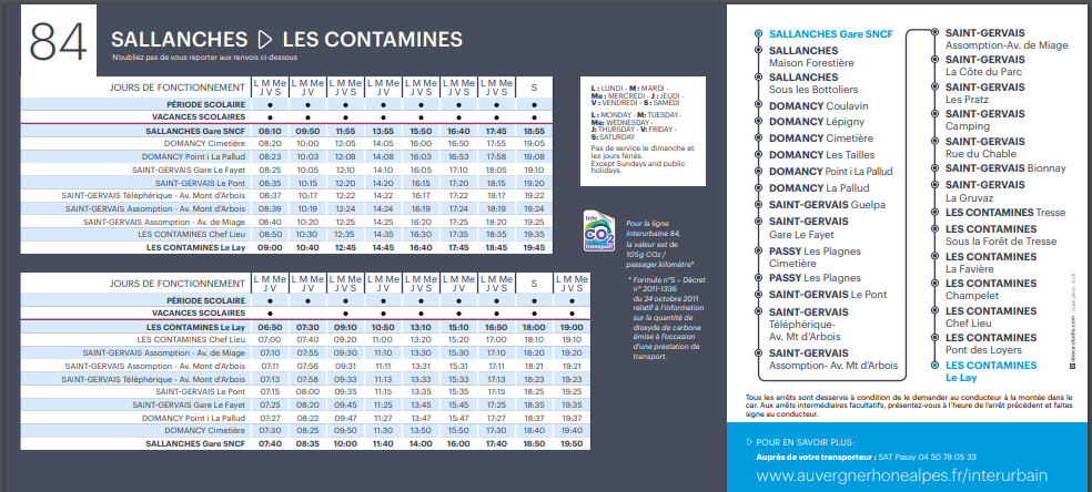
Bus from Tresse to Les Contamines is 1.5 Euro each.
http://www.sat-montblanc.com/horaire-timetables/ligne-84-sallanches-st-gervais-les-contamines.aspx
Taxi service:
Taxi Besson www.taxi-montblanc.com +33 4.50.78.07.67
Hotel:
Chalet-Hotel Gai Soleil
288 chemin des Loyers
74170 Les Contamines-Montjoie
tél.:+33(0)4 50 47 02 94
contact@gaisoleil.com
http://www.gaisoleil.com/en/Chalet-hotel
Places to eat enroute (we ended up eating snacks along the trail):
Col de Voza (1 mile from where the tram lets out)
https://www.apas.asso.fr/vacances/col-de-voza-ete
https://www.ternelia.com/fr/montagne/village-vacances-saint-gervais-mont-blanc
There is also a bar and snack bar with terrace / solarium.
Refuge du Fioux (2 miles from where the tram lets out)
http://www.montourdumontblanc.com/fr/il4-refuge_i32356-refuge-du-fioux.aspx
Half-board , Picnic , Reservations , Lunch , Dinner , Breakfast , free drinking water , hot water thermos
located in the middle of the mountains, very quiet. Panoramic terrace, view on the montjoly, the glacier of Bionnassay, the dome of taste
Auberge de Bionnassay (About 3 miles)
http://www.auberge-bionnassay.com/
The restaurant consists of 3 rooms will allow you to enjoy authentic Savoyard cuisine while keeping an eye on the animals of the sheepfold (llama, annesse, rabbits, chickens ...). A terrace awaits you to enjoy the exceptional view of the Mont-Blanc massif including the Aiguille and the Dôme du Goûter, Aiguille de Bionnassay and Mont-Vorasset.
TMB Day 3: Les Contamine to Les Chapieux
Distance: 7.5 hours / 11 miles
Height Gain: 4,317 feet / Height Loss: 3,046 feet
Transport Options: Bus Les Contamine to Notre Dame de la Gorge, Shuttle or taxi from Les Chapieux to Refuge les Mottets
This hike will be tougher than either of the first two days. There are two options, one which goes directly to Refuge les Mottets through a higher pass, and one that goes through a slightly lower pass to Les Chapieux. If there is bad weather, or snow on the passes, it is recommended to take the lower route to Les Chapieux and take a shuttle or taxi close to Refuge de Mottets. Both routes start at Les Contamine and pass by the Notre Dame de la Gorge. From there, it is a steep ascent of 850 feet to the refuge Nant Borant. Afterwards, the trail becomes less steep and you steadily climb up past Refuge de la Balme and Col du Bonhomme, before reaching Col de La Croix. The view hiking to the Col involves beautiful panoramas of Plan Jovet. When you finally reach the col, there is a stunning view back into Val Montjoie, from whence you came. Finally, the two paths diverge at Col de la Croix, the high route alternative climbing upwards to Col des Fours (8,743 feet), one of the highest spots on the TMB, while the main route immediately descends to Les Chapieux. The higher route avoids a section of road between Les Chapieux and Refuge de Mottets. If there is bad weather, you can take a taxi or shuttle from Les Chapieux to Refuge les Mottets, saving about an hour of road walking.
Take a taxi to the end of the road (Notre Dame de la Gorge) in the morning to cut off ~2 or 3 miles. We did get a ride to the church and since this was the hardest day it was nice to eliminate some road hiking.
Lunch Options:
Refuge Nant Borrant (Mile 2 or 4)
http://www.refuge-nantborrant.com/home/
Our shady terrace offers you an oasis of calm with a mountain ambiance.
You can try our specialities and quench your thirst at any time of the day.
Refuge de la Balme (Mile 4 or 6)
http://www.montourdumontblanc.com/uk/il4-refuge_i32361-refuge-de-la-balme.aspx
Lunch meal and drinks Takeaway picnic.
Refuge de La Croix du Bonhomme (Mile 8 or 10), we had a beer here with our bag lunch and were glad we did not stay here as it looked fairly unkempt.
http://lerefugedubonhomme.free.fr/
During the day we propose to the card tea, coffee, chocolate, soda, draft beer, wine, omelette, salad, dish of the day, cheese, plate of charcuterie, pie of the day, chocolate cake ...
Taxi service:
Taxi Besson www.taxi-montblanc.com +33 4.50.78.07.67
Hotel:
Refuge Auberge de la Nova
Les Chapieux
73700 Bourg St Maurice
Téléphone: 04 79 89 07 15
http://www.refugelanova.com/en/
TMB Day 4: Les Chapieux to Refugio Elissabetta
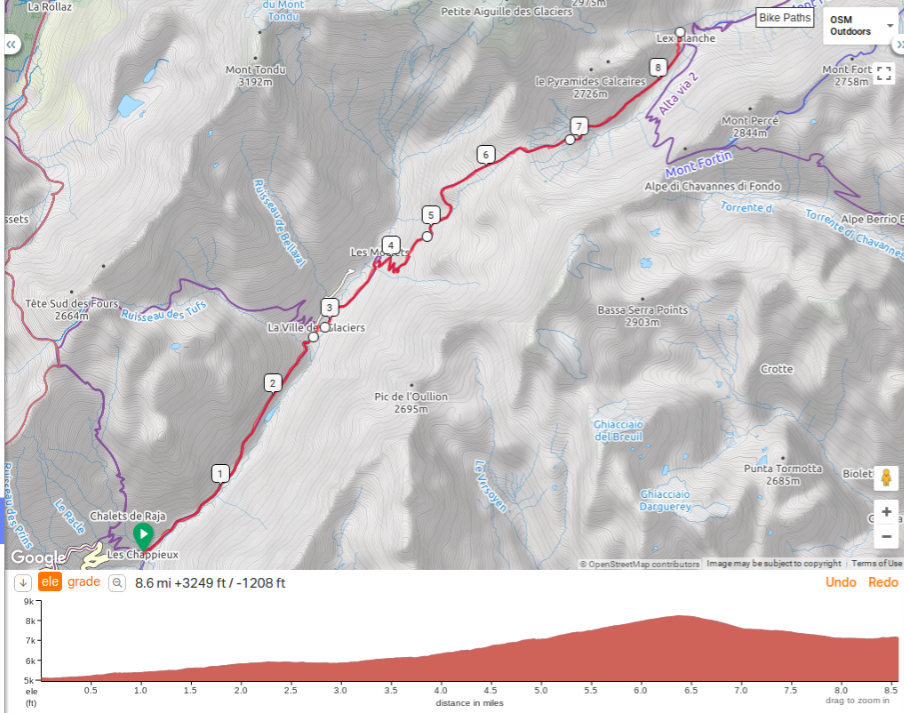
taxi or shuttle from Les Chapieux to Refuge les Mottets (~3.5 miles) Only really goes to La Ville des Glaciers.
Refuge de Mottets– Col de la Seigne – Refugio Elissabetta
Distance: 4 hours / 6 Miles
Height gain: 2,952 feet / Height loss: 846 feet
Transport Options: none
Today you will leave France and enter Italy via Col de la Seigne. Although a short day, there is still a lot of elevation gain as you will be passing over Col de la Seigne, which has a height of 8,254 feet. Not very long or hard, there are a few steep sections on the way to the Col. At the top, you will have a view of both France and Italy, quite stunning! In Italy, you will gaze onto the Val Veni It’s then a steady descent down to Refugio Elisabetta, which sits at 7,200 feet above sea level on the side of a mountain.
Refugio Elisabetta. Great atmosphere. Some travelers are turned off by the large dortoirs. Reserve a spot in a 4 - 7 dormitory room early, or if you plan really well, the only double room they have. Dinner is done in an early and late shift. Food is some of the best on the TMB and there is a good selection of beer and wine. Davide and Marta run the hut, so be friendly and they are sure to return in kind.
Taxi service:
Taxi Besson www.taxi-montblanc.com +33 4.50.78.07.67 (Make sure you double check with Refuge Auberge de la Nova that you are on the taxi list, we had called and reserved a spot but were not on the list the owner had. There happened to be two spots on an early taxi so we hustled and got a ride, definitely worth skipping the road hike up the canyon)
Hotel:
ELISABETTA REFUGE - 2195M
MONT BLANC / LOC. LEX BLANCHE
VAL VENY / COURMAYEUR (AO)
INFO@RIFUGIOELISABETTA.COM
TEL: +39 0165 844080
http://www.rifugioelisabetta.com/
TMB Day 5: Refugio Elissabetta to Courmayeur
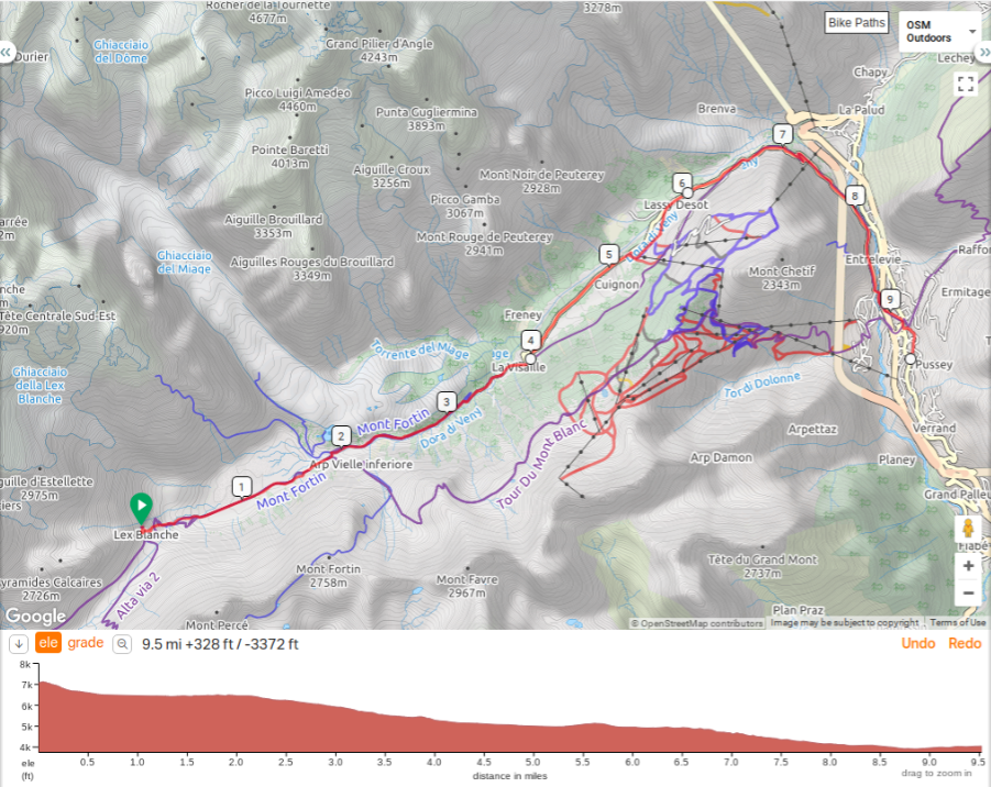
Catch bus at La Visaille (at mile 4)
Distance: 5.5 hours / 11.1 miles
Height Gain: 1,509 feet / Height Loss: 5,118 feet
Transport Options: Bus from La Visaille to Courmayeur (bad weather alternative), Cable car from Plan Checrouit to Courmayeur
This is also a short day, however with a lot of elevation loss towards the end of the day when you descend down into Courmayeur. The day starts with a descent from Elisabetta to Lake Combal situated below. After the lake, if the weather is bad, then it is advised to descend into Val Veni and continue walking the valley. There are buses available in the valley to take you to Courmayeur. If the weather is good, you can climb to the Mont Favre spur, the highest point of the trek at 7,972 feet and then continue on the high route, which has some really nice views of Mont Blanc and the surrounding peaks from the opposite side of the mountain you saw on the first day. Once you reach Plan Checrouit, if your legs are a bit worn out, you can take a cable car down to Courmayeur. The cable car can save about 1,900 feet of elevation loss. (Not sure if cable car is running!!!! It was not in September) We ended up taking the low route due to thunderstorm possibility)
Transport Options: Bus from La Visaille to Courmayeur (bad weather alternative), the bus service in September was pretty good. Cable car from Plan Checrouit to Courmayeur (not running in September). We hoped on the bus at the Plan Ponquet stop and rode it into Courmayeur. I would recommend that as the road gets quite narrow down the hill into town.
Taxi service and other contacts:
Public transport of the line - SAVDA (Piazzale Monte Bianco) - 0165841397
http://www.savda.it/en/110/servizi-courmayeur/ (Get app for purchasing tickets? Purchased on bus )
http://www.autourdumontblanc.com/en/index.cfm/public-transport.html
• TAXI (Piazzale Monte Bianco) - 0165842960 +39 0165 842960
/ • Municipal Police - 0165831334
https://www.lovecourmayeur.com/en/
Hotel:
Hotel Lo Scoiattolo
Viale Monte Bianco 50 11013 Courmayeur (AO), Italy
Tel: +39 0165846716 | Fax: +39 0165843785
info@loscoiattolohotel.it
https://www.loscoiattolohotel.it/
TMB Day 7: Courmayeur to Rifugio Bonatti
Sunday September 8
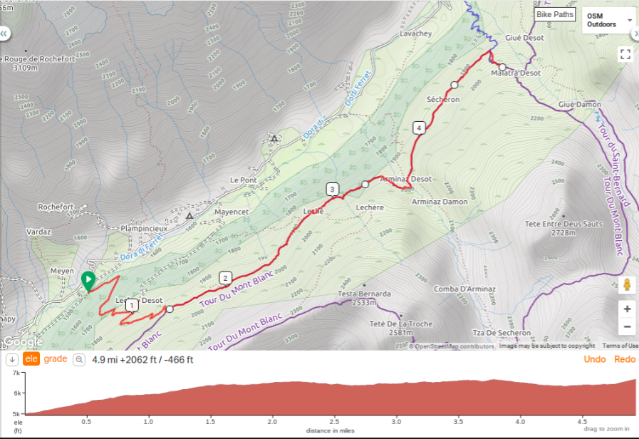
You can also take a bus to La Vachey and hike steeply 1.5 hours up to Rifugio Bonatti. We did the whole hike and it was amazing.
Distance: 4.5 to 7 hours / 7.4 miles, 8.7 miles or 10 miles depending on route
Height Gain: 2821, 4753 or 5239 feet / Height Loss: 2290 or 1804 by variants
Transport Options: Bus from Courmayeur to La Vachey
One of the prettiest stages of the tour, the flank of Mont de la Saxe and the glaciers of Planpincieux and Frebouze are on display throughout most of the day. Running beneath you is the Val ferret. Also, keep your eyes peeled for blueberry, which can be found off to the side of the path. Today, you have the choice to follow the new main route to Refugio Bonatti, which takes a lower path that avoids a lot of elevation gain, or one the old TMB routes, which rise higher and give even more impressive views of the Mont Blanc Massif. The alternative higher routes push you to 8,280 feet, whereas the main route levels out around 6,600 feet. The high route travels along the Mont de la Saxe crest and has been regarded by many as one of the best viewpoints of the south side of the Mont Blanc range. For the weary hikers, you can also take a bus to La Vachey and hike steeply 1.5 hours up to Rifugio Bonatti.

*** Could also skip this day, spend another night in Courmayeur and take the bus to Arp Nouvaz Cap the next day (saves ~ 3 miles, mostly downhill).
Taxi service and other contacts:
Public transport of the line - SAVDA (Piazzale Monte Bianco) - 0165841397
http://www.savda.it/en/110/servizi-courmayeur/ (Get app for purchasing tickets? Buy on the bus)
http://www.autourdumontblanc.com/en/index.cfm/public-transport.html
• TAXI (Piazzale Monte Bianco) - 0165842960 / • Municipal Police - 0165831334
Hotel:
Rifugio Bonatti
loc. Malatrà, Val Ferret,
11013, Courmayeur (AO)
mob. +39 335 6848578
rifugiobonatti@gmail.com
https://www.rifugiobonatti.it/?lang=en
TMB Day 7: Courmayeur to Rifugio Bonatti
You can also take a bus to La Vachey and hike steeply 1.5 hours up to Rifugio Bonatti (we knew some ladies that did this and they said the climb up was very steep and took them a couple of hours).
Distance: 4.5 to 7 hours / 7.4 miles, 8.7 miles or 10 miles depending on route
Height Gain: 2821, 4753 or 5239 feet / Height Loss: 2290 or 1804 by variants
Transport Options: Bus from Courmayeur to La Vachey
One of the prettiest stages of the tour, the flank of Mont de la Saxe and the glaciers of Planpincieux and Frebouze are on display throughout most of the day. Running beneath you is the Val ferret. Also, keep your eyes peeled for blueberry, which can be found off to the side of the path. Today, you have the choice to follow the new main route to Refugio Bonatti, which takes a lower path that avoids a lot of elevation gain, or one the old TMB routes, which rise higher and give even more impressive views of the Mont Blanc Massif. The alternative higher routes push you to 8,280 feet, whereas the main route levels out around 6,600 feet. The high route travels along the Mont de la Saxe crest and has been regarded by many as one of the best viewpoints of the south side of the Mont Blanc range. For the weary hikers, you can also take a bus to La Vachey and hike steeply 1.5 hours up to Rifugio Bonatti.
*** Could also skip this day, spend another night in Courmayeur and take the bus to Arp Nouvaz Cap the next day (saves ~ 3 miles, mostly downhill).
Taxi service and other contacts:
Public transport of the line - SAVDA (Piazzale Monte Bianco) - 0165841397
http://www.savda.it/en/110/servizi-courmayeur/ (Get app for purchasing tickets?)
http://www.autourdumontblanc.com/en/index.cfm/public-transport.html
• TAXI (Piazzale Monte Bianco) - 0165842960 / • Municipal Police - 0165831334
Hotel:
Rifugio Bonatti
loc. Malatrà, Val Ferret,
11013, Courmayeur (AO)
mob. +39 335 6848578
rifugiobonatti@gmail.com
https://www.rifugiobonatti.it/?lang=en
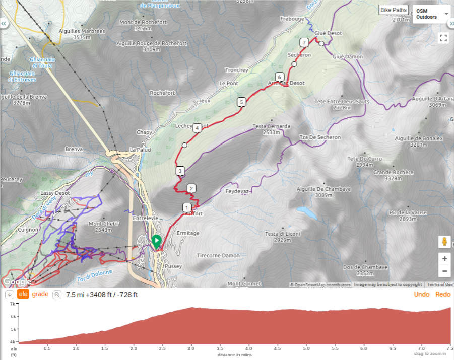
TMB Day 8: Rifugio Bonatti to La Fouly
There is a bus that runs from the town of Ferret to La Fouly (Saving ~1-2 miles). I don’t recommend the first transport from La Vachey to Arnuva, because you would need to detour down into the valley to reach La Vachey, which has a lot of elevation change in a short amount of time. (We found that the bus driver takes an hour break about 2 in the afternoon in Ferret so we just ended up walking down the road to La Fouly which was a nice hike with dramatic views. We noticed the bus was jammed packed with hikers when it came through La Fouly)
Distance: 6.5 hours / 12.4 Miles
Height gain: 2,936 feet / Height loss: 4,625 feet
Transport Options: Bus from La Vachey to Arnouva, Bus from Ferret to La Fouly
Today will be a bit tougher than yesterday. You will say goodbye to Italy and finally arrive into Switzerland. The first stretch from Bonatti to Refugio Elena has some slight elevation change as you descend back into the Val Ferret and allows you to enjoy the sweeping views of the Massif and the Val Ferret. After Elena, you will start the steep ascent to the Grand Col Ferret; waiting for you on the other side is Switzerland. At 8,323 feet, the Col Ferret is about the same height as Col de Seigne a few days earlier. In Switzerland, the big mountain views are replaced by a pastoral and agricultural setting. There is a charm to the Val Ferret, with cowbells often heard and tiny villages that seem to be stuck in time. If you are getting tired towards the end, there is a bus that runs from the town of Ferret to La Fouly. It saves about an hour of hiking time. I don’t recommend the first transport from La Vachey to Arnuva, because you would need to detour down into the valley to reach La Vachey, which has a lot of elevation change in a short amount of time.
*** Could also skip Rifugio Bonatti , spend another night in Courmayeur and take the bus to Arp Nouvaz Cap the next day (saving ~3 miles)
Taxi service and other contacts:
Public transport of the line - SAVDA (Piazzale Monte Bianco) - 0165841397
http://www.savda.it/en/110/servizi-courmayeur/ (Get app for purchasing tickets?)
http://www.autourdumontblanc.com/en/index.cfm/public-transport.html
• TAXI (Piazzale Monte Bianco) - 0165842960 / • Municipal Police - 0165831334
Swiss Transportation

Taxi: http://www.taxifenyx.ch/en/
Phone: call in French in English text message +41 (0) 79-773.77.40
Hotel:
Hotel Edelwiess
Route de Ferret 44
CH-1944 La Fouly
Tel. 0041 (0)27 783 26 21
Fax 0041 (0)27 783 28 20
http://www.ledelweiss.ch/Lafouly/index.php
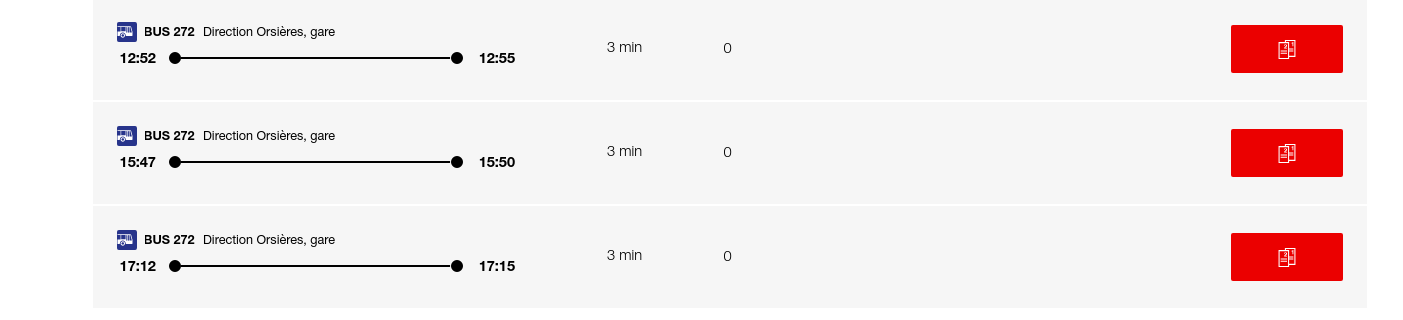
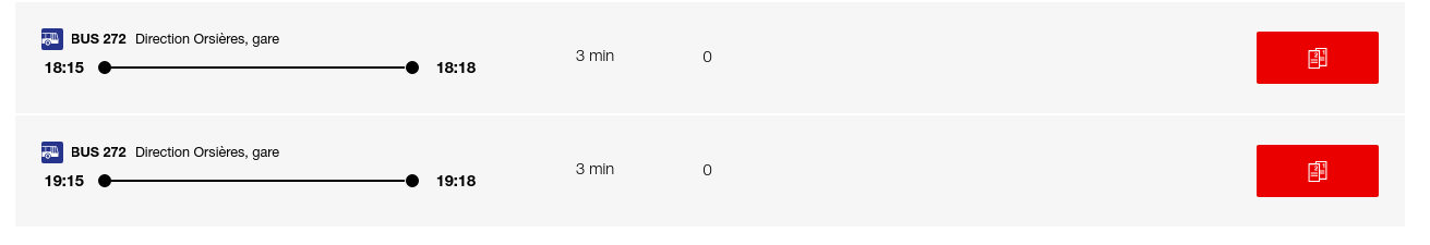
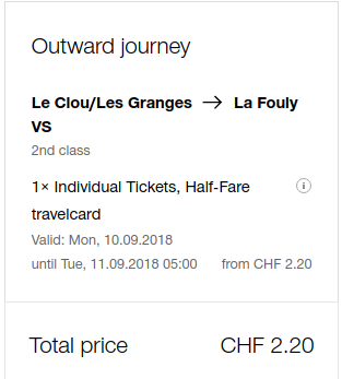
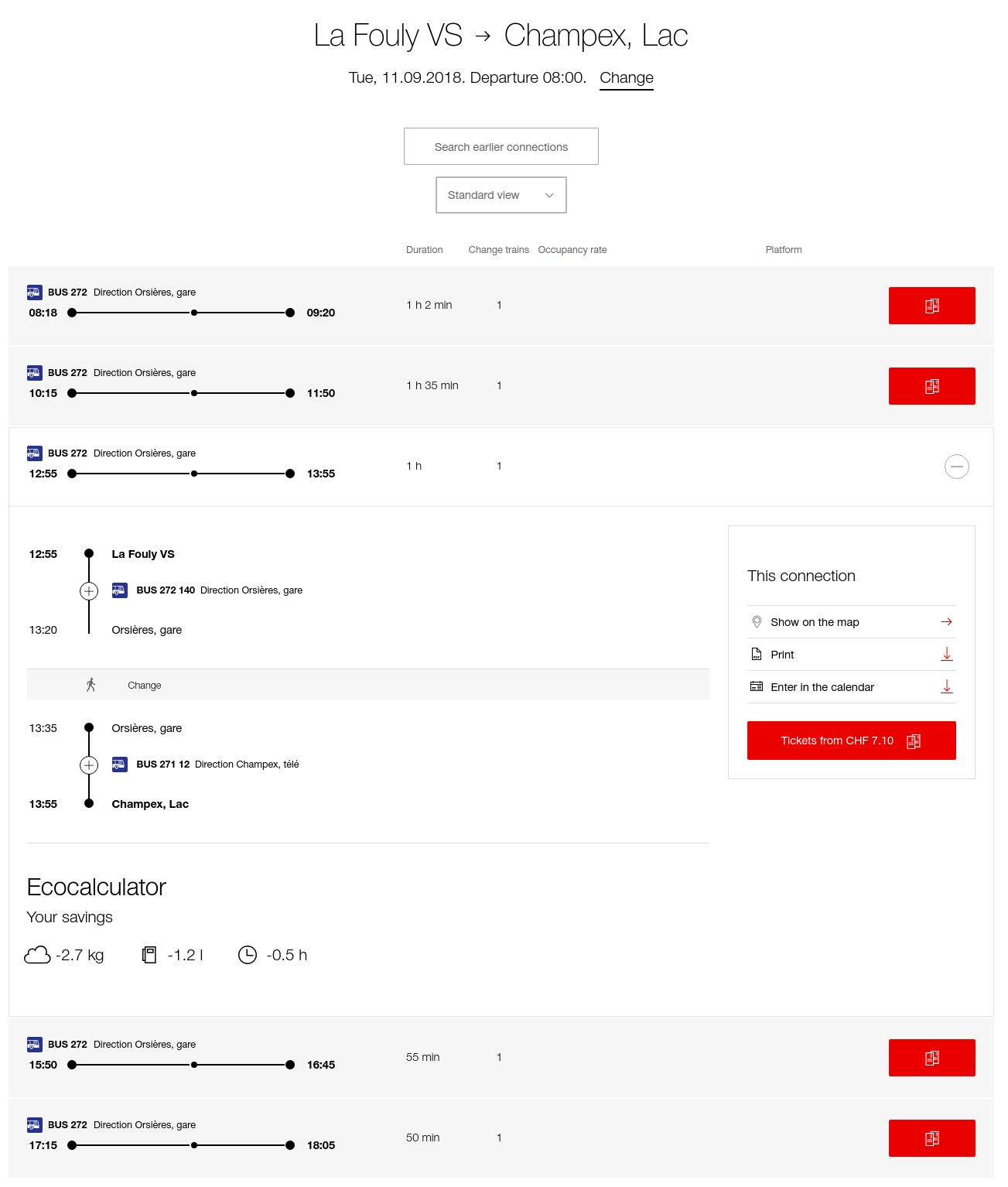
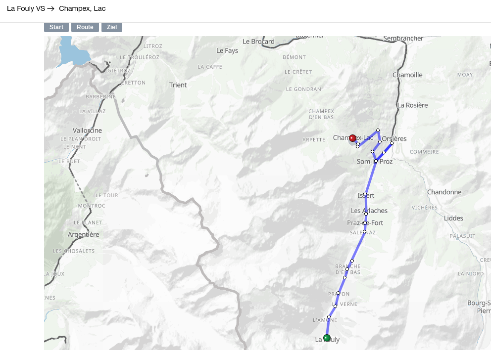
TMB Day 9: La Fouly to Champex
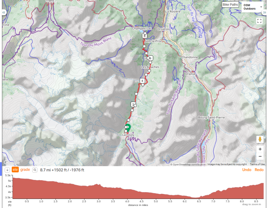
Distance: 4.5 hours / 9.3 Miles
Height gain: 1,377 feet / Height loss: 1,853 feet
Transport Options: Bus from La Fouly to Champex
This will probably be the easiest day of your tour. There are no passes or cols to conquer and you will be traveling through a valley most of the trek. Although there are few big mountain views here, there are several charming villages to pass through. After leaving La Fouly, you will begin a slow descent, passing by Praz de Fort before arriving at the low point of the trek in Issert. Flowers, bees and butterflies make this tiny hamlet in interesting stop before your steady descent through a forest laden with wooden gnomes and mushrooms leading to Champex. If you are in need of a break, there is a bus from La Fouly to Champex; but this shouldn’t be a hard day to handle if you’re still feeling fit. (Actually a very nice hike down the valley, glad we did not skip it by taking a bus. The climb up to Champex was a bit of a challenge as it was hot and the hike is in the sun. Also the mileage was about a mile longer)
Accommodation – Hotel Splendide two interconnected rooms with ensuite in one room (the single room needs to share the bathroom with the double). Confirmed without deposit needed.
Stuff to do:
Taxi service and other contacts:
Swiss Transportation
Taxi:
http://taxi-grand-saint-bernard.ch/
+ 4179 217 08 27 or + 4179 736 73 73
Of course, we will also be happy to receive an email from you at the following address:
mathieu.jc@gmail.com or info@taxi-des-combins.ch
phone call in French in English text message +41 (0) 79-773.77.40
Hotel:
Splendide Hotel - Richer-Lonfat Family - 1938 Champex-Lac - Switzerland
+41 (0) 27 783 11 45
hotel-splendide@bluemail.ch
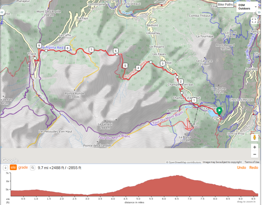
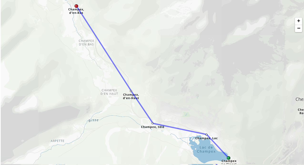
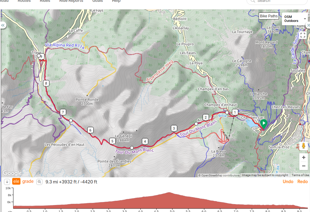
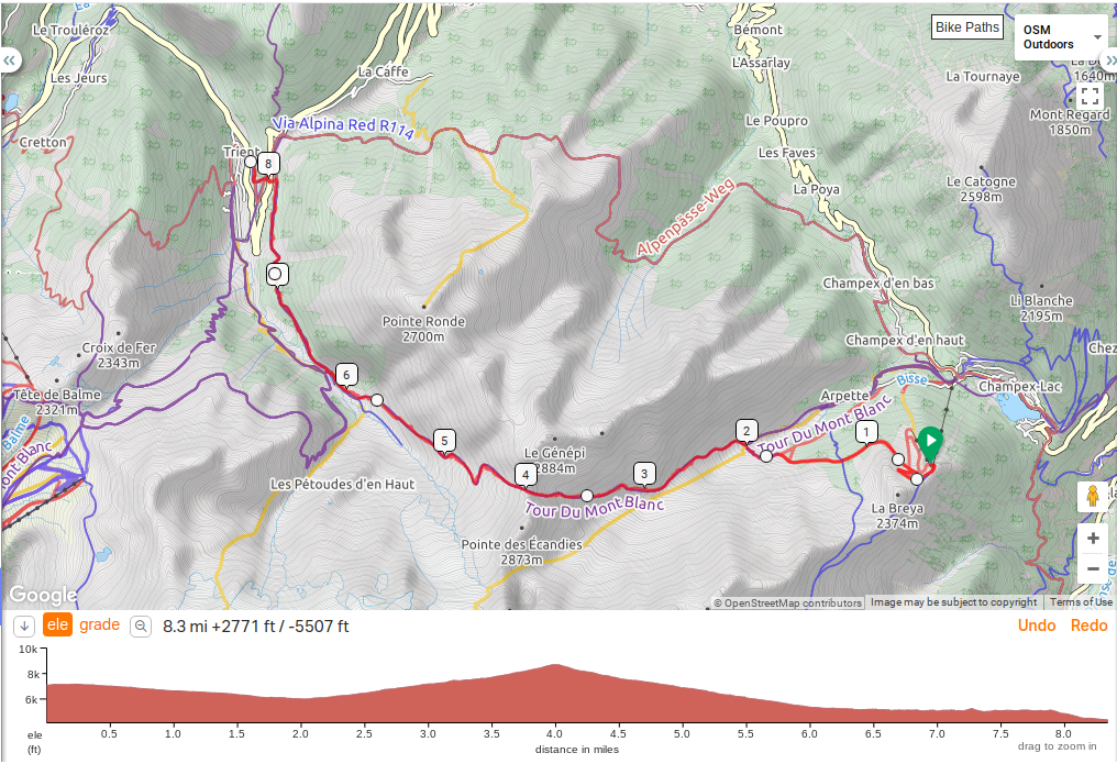
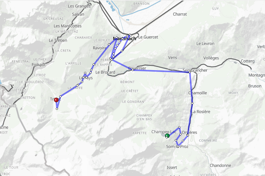
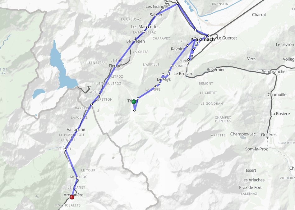
TMB Day 11: Champex to Trident
Main Route: alt high route towards bottom
Distance: 5.5 hours / 9.5 Miles
Height gain: 2,434 feet / Height loss: 2,237 feet
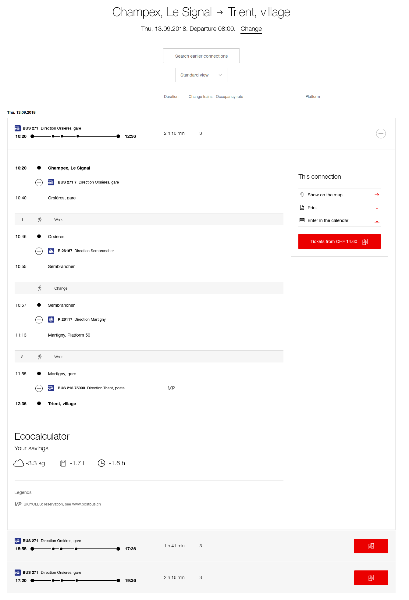
Transport Options: Postbus and Train (Champex – Orsieres – Martigny – Forclaz)
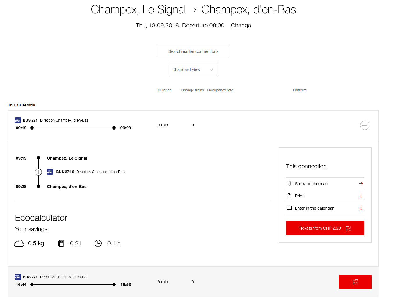
Hikers have two options reach Trient. The main route goes over Col de Forclaz (5,006 feet), and then ascends higher to “Alp Bovine”, the highest point of the trek at 6,692 feet above sea level. Although perhaps not as spectacular as the alternative high route, the main route still impresses with views of the Town of Martigny which seems to be miles below. The path snakes its way across fields, meadows and forests and provides a good amount of elevation change and challenge. The higher route alternative, passing through Fenetre d’Arpette (8,743 feet) should only be attempted in good weather and without snow. It is the highest point on the TMB and there is some scrambling necessary at the top. Caution is advised. Still, the route has an amazing view or “window” onto a different landscape when you finally reach the top. Also, there is the view of Trient Glacier which is quite beautiful, although it is shrinking in size.
Taxi service and other contacts:
Swiss Transportation
Can cut 2 miles of walking off by using bus
Taxi:
http://www.champex.info/transport
http://taxi-grand-saint-bernard.ch/
+ 4179 217 08 27 or + 4179 736 73 73
Of course, we will also be happy to receive an email from you at the following address:
mathieu.jc@gmail.com or info@taxi-des-combins.ch
Hotel:
Hôtel du Col de la Forclaz
Fam. J.C. Gay-Crosier
Ch-1929 Trient
Tél. 027 722 26 88
Fax. 027 723 18 07
colforclazhotel@bluewin.ch
http://www.coldelaforclaz.ch/index.php/en/
High Route:
Can cut about a mile off taking bus to Champex, télé stop.
Can cut about a mile off and 1000 vertical feet of climbing (add 800 vertical of descent) using chair lift and bus
If bad weather:
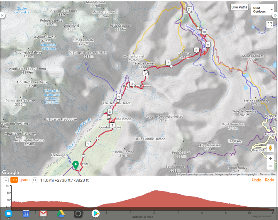
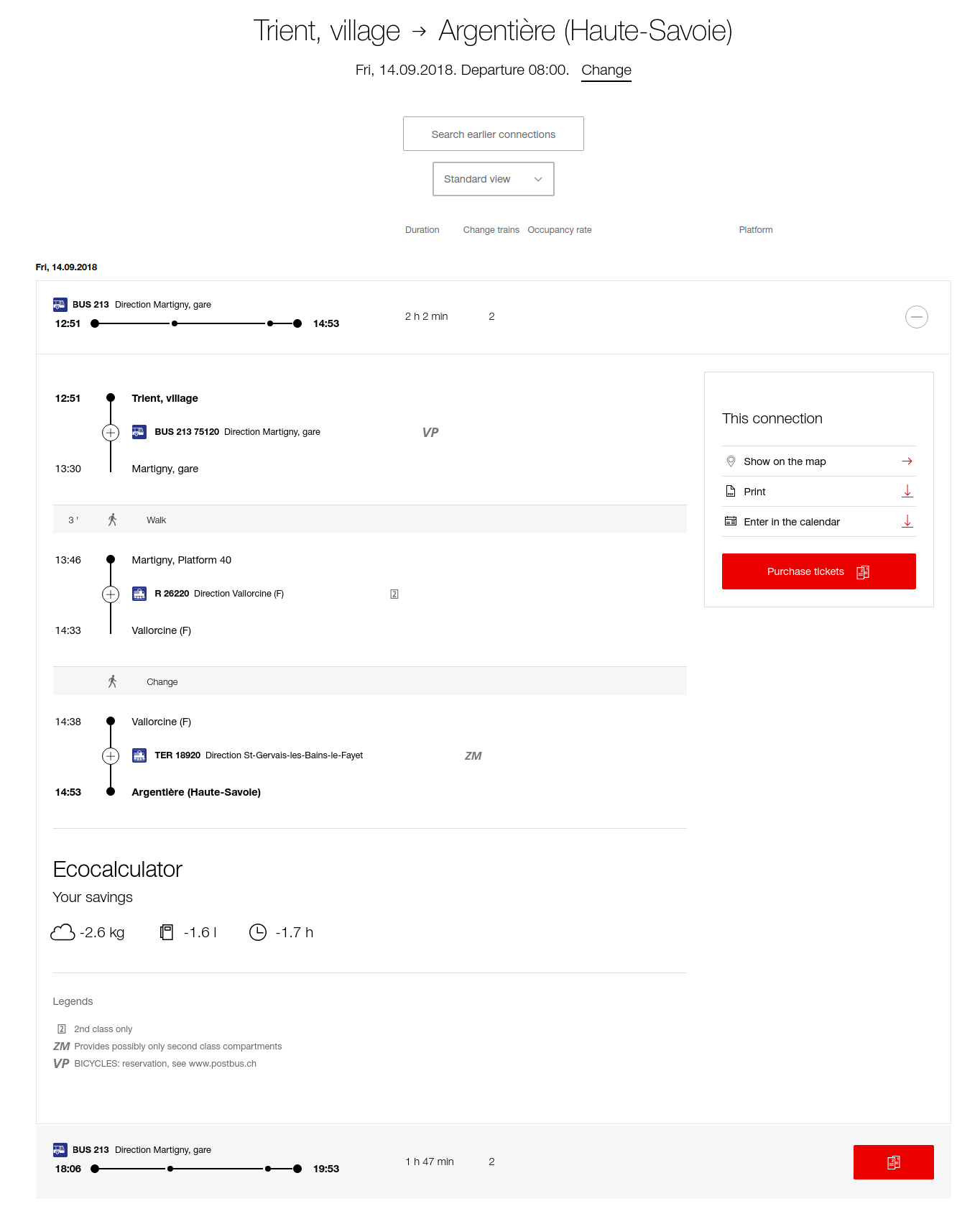
TMB Day 12: Trident to Argentiere
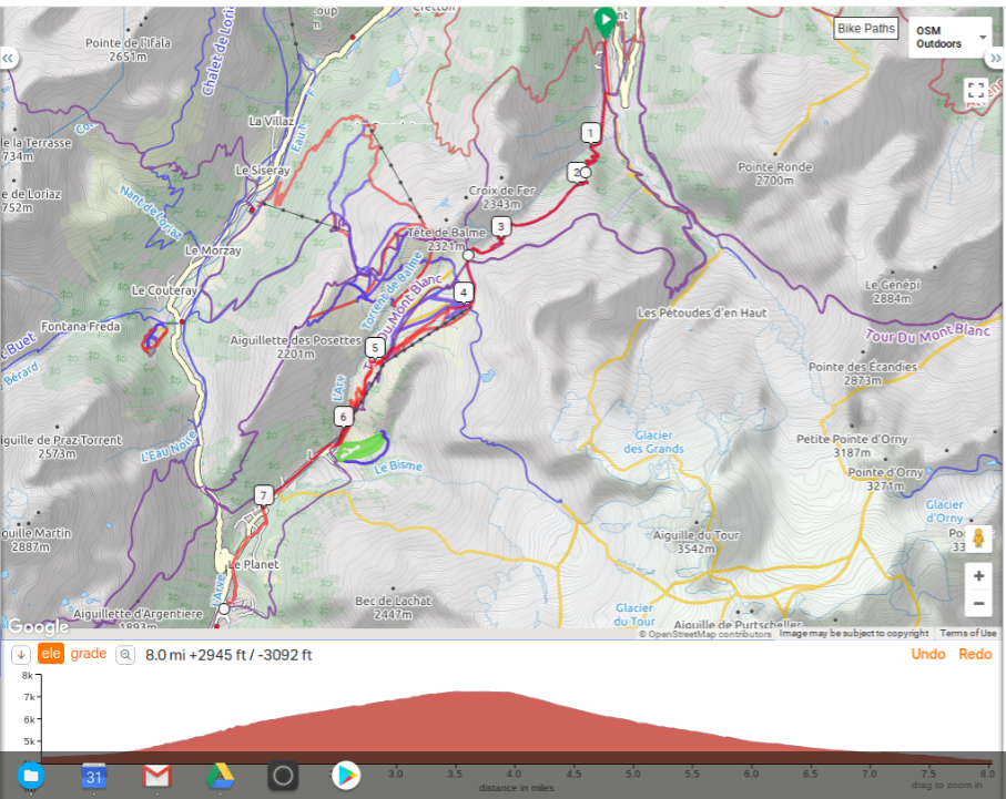
Distance: 6 hours / 9.4 Miles
Height gain: 3,507 feet / Height loss: 3,864 feet (not including descent into Argentiere)
Transport Options: Taxi from Tre Le Champ.
Although there is a lot of elevation gain and loss, most of the trek, apart from the descent from Aiguillette de Posettes (7,221 feet), is at a relatively amicable angle. Today you will have the first glimpse of the Mont Blanc summit since leaving Refugio Bonatti. After passing Col de Balme, you will reenter France. If there is bad weather, head to Charmillion. If the weather is good, you can head north to Le Peuty. After reaching Tre le Champe, you can continue on to Argentiere if you desire private accommodation, a 25 minute detour off the main route. The Argentiere valley has a better infrastructure and more amenities. Alternatively, you could call a taxi from Tre le Champ and hitch a ride down to Argentiere. (We took the old route and the lower lift was broken so we ended up hiking the whole way, a beautiful hike with a view of the valley in front of you. You do hike on the road for the last 2+ miles but not too bad for traffic)
Taxi service and other contacts:
Ski lift to eliminate a lot of downhill and about 2 miles of hiking:
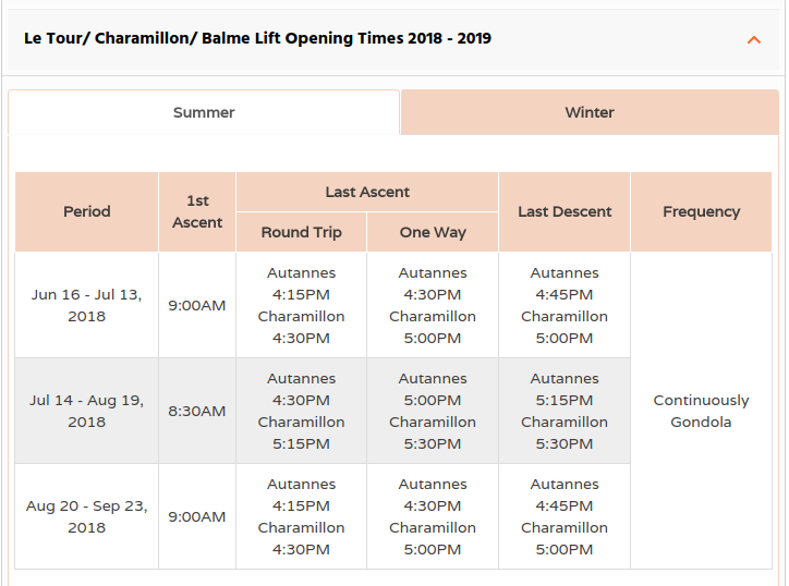
https://www.chamonix.net/english/lift-systems/dates-times#le-tour-balme-lift
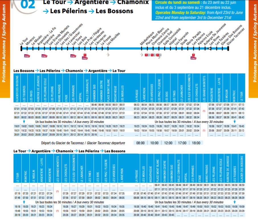
Bus from Le Tour to Argentiere, cuts off ~2 miles of road walking.
Taxi:
Hotel:
Hotel Couronne
285, rue Charlet Straton
74400 Argentière
+33 (0)4 50 54 00 02
info@hotelcouronne.com
colforclazhotel@bluewin.ch
http://www.coldelaforclaz.ch/index.php/en/
Just in case Trient to Argentiere bus/train
TMB Day 13: Argentiere to Chamonix
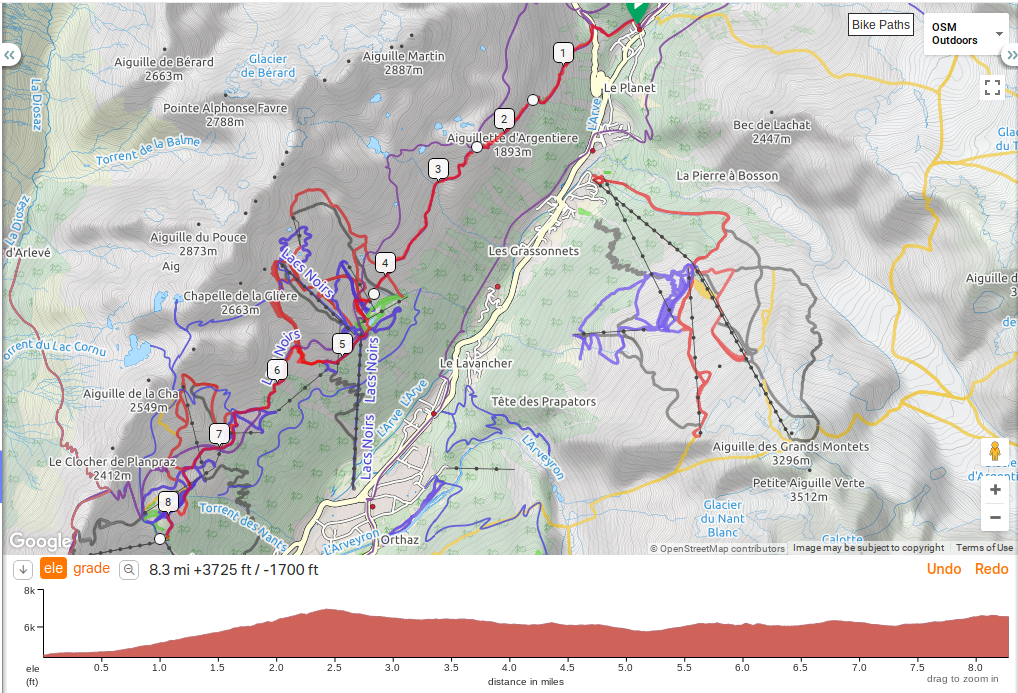
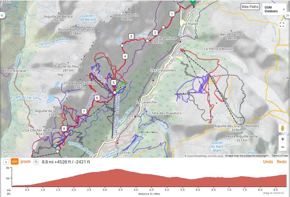
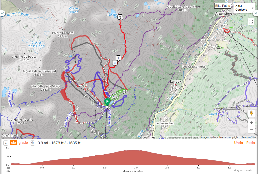
Maybe take the lift up and hike to Lac Blanc?
Distance: 8 hours / 10 Miles
Height gain: 4,937 feet / Height loss: 843 feet (not including descent into Argentiere)
Transport Options: Cable Car at Refugio Le Flegere, Cable Car at Plan Praz, Cable Car at Le Brevent
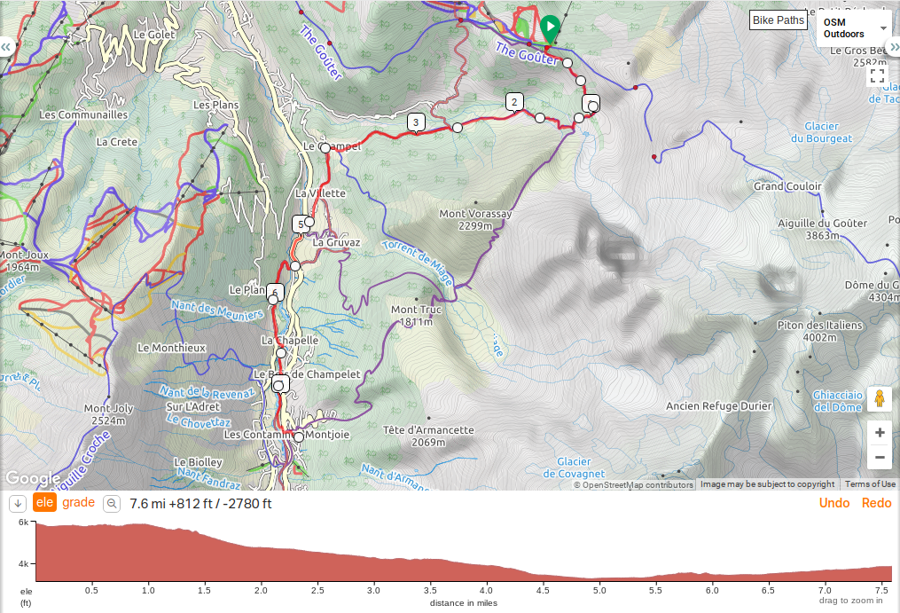
Today has some of the best views of the entire tour. The main route goes to Refuge le Flegere via a series of ladders and metal steps hammered into stone. None of the ladders are higher than 30 feet or so, but for those that wish to avoid this section, there is an alternate route that goes through Col des Montets. The alternate route is a bit steeper and gains elevation quicker than the main route. Soon after the two routes come together there is another detour that goes to Lac Blanc. The lake provides a picturesque view of Mont Blanc with the lake set in the foreground – a good spot for a picture of the peak reflecting off the shimmering blue water. The trip to Lac Blanc does take an extra 45 minutes and adds about 600 feet of elevation gain and loss. After reaching Refuge le Flegere, you then have a decision to make. You can take a gondola down to finish your tour or you can continue on towards Le Brevent. If you do continue, in approximately two hours, you will reach another opportunity to take a cable car down to Chamonix at Plan Praz. It’s relatively flat from Flegere to Plan Praz, however afterwards the angle gets steeper on your final assent which takes an additional 2 hours. The final 200 meters is enclosed in a hollow where your vision is restricted (two ladders are on this section as well). You’ve seen the view from Le Brevent on the first day, and you will remember how stunning it was.
This route is designed so that you can have two chances to see Mont Blanc from arguably the best viewpoint of the tour. If the weather was bad on the first day, you have another chance today. Once you reach the top, you can take the gondola back down to Chamonix to complete your tour.
Taxi service and other contacts:
Bus from Argentiere to Montroc, cuts off 1.5 miles of road walking. Can also take to Chamonix and then lift up.
Hotel:
LE MORGANE CHAMONIX
145, avenue de l'Aiguille du Midi
74 400 Chamonix Mont-Blanc
Fax : +33(0)4 50 53 28 07
reservation@hotelmorganechamonix.com
https://www.morgane-hotel-chamonix.com/en/
Copyright 2019, Richard J. Moore
keywords: Tour du Mont Blanc, Hiking, Trekking, TMB
description: Detailed day by day planning for our 2018 Tour du Mont Blanc